Rivers Planning
Below the Falls of the James
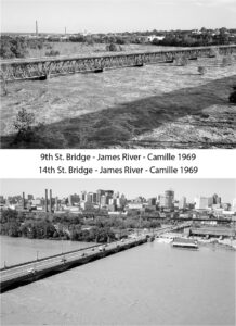
The Below the Falls of the James project is an effort to study uses and resiliency along a section of the James River estuary. The study area stretches from the falls in downtown Richmond eastward to the confluence with the Chickahominy River in Charles City County. The study area includes member localities in PlanRVA: Charles City County, Chesterfield County, Henrico County, and the City of Richmond.
The James River estuary is a unique resource that we all must share. There is value in discussing and learning about how we can sustainably share the river corridor. As a first step in answering these questions, PlanRVA has engaged with regional stakeholders to discuss key issues. The first products produced to facilitate this conversation are the Below the Falls Mapping Application and a Below the Falls Ecology StoryMap.

The Below the Falls project aims to answer two main questions

Explore the geography of the Below the Falls area.
Learn about the habitats, plants, and animals of the Below the Falls area.
Estuaries
Estuaries are coastal bodies of water that have mixed fresh and salty water. The water in estuaries is mixed because they are fed by rivers but also a connection with oceans. Estuaries have a barrier to the sea, that protects them from ocean energy, but, estuaries still connect with the sea. Because of this connection with the sea, estuaries are strongly influenced by tides (NOAA).
About the Osprey Nest
The RVA Osprey Cam first came to life in the late winter of 2017. Set on a bridge piling in the shadow of Richmond’s skyline and hemmed by James River Park land, the RVA Osprey Cam was a huge hit in the city and beyond - generating nearly a quarter of a million views. The stream showcased an osprey pair, later named Maggie and Walker by our viewers, as they nested, laid eggs and reared young. It’s a project that could not have happened without the support of the Friends of the James River Park.

Atlantic Sturgeon
Many believed the Atlantic sturgeon were gone from the Chesapeake Bay watershed. They hadn’t been sighted in rivers that fed the bay for decades. The sturgeon, one of the oldest and largest fish on earth (growing upwards of 14 feet long and weighing more than 800 pounds) were once found in huge numbers along the Atlantic Coast and coastal rivers from Canada to Florida. They were an important food for indigenous peoples along the coast and likely saved Jamestown colonists from starvation.


This project, Task # 48 was funded by the Virginia Coastal Zone Management Program led by the Virginia Department of Environmental Quality through Grant FY18 #NA18NOS4190152 of the US Department of Commerce, National Oceanic, and Atmospheric Administration, under the Coastal Zone Management Act of 1972, as amended. The views expressed herein are those of the authors and do not necessarily reflect the views of the US Department of Commerce, NOAA, or any of its sub-agencies.
