Lower Chickahominy
Land & Water Use in the Study Area
Development Patterns & Population
The counties of the Lower Chickahominy are historically rural but have experienced growth and development pressures in recent decades as urban areas associated with Richmond and Hampton Roads expand.
According to 2020 American Community Survey Census data, the total population of the three counties was 108,472. James City County is the most populous county with a total population of 78,016 people. The population estimate of New Kent County is 23,474. Charles City County is the least populous and most rural of the three counties with a total estimated population of 6,982.
From 2010 to 2020, the watershed experienced a 17% population increase, going from 92,694 total residents to 108,472. According to data from UVA's Weldon Cooper Center for Public Service, James City County experienced an estimated 16.4% population increase (from 67,009 to 78,016) from 2010 to 2020, and New Kent experienced a 27.4% increase (from 18,429 to 23,474). Looking into the future, the Weldon Cooper Center estimates that by 2040, the Lower Chickahominy Watershed will experience a 32.8% population increase, with totals jumping from 108,472 In 2020 to 144,003 in 2040.
Drinking Water
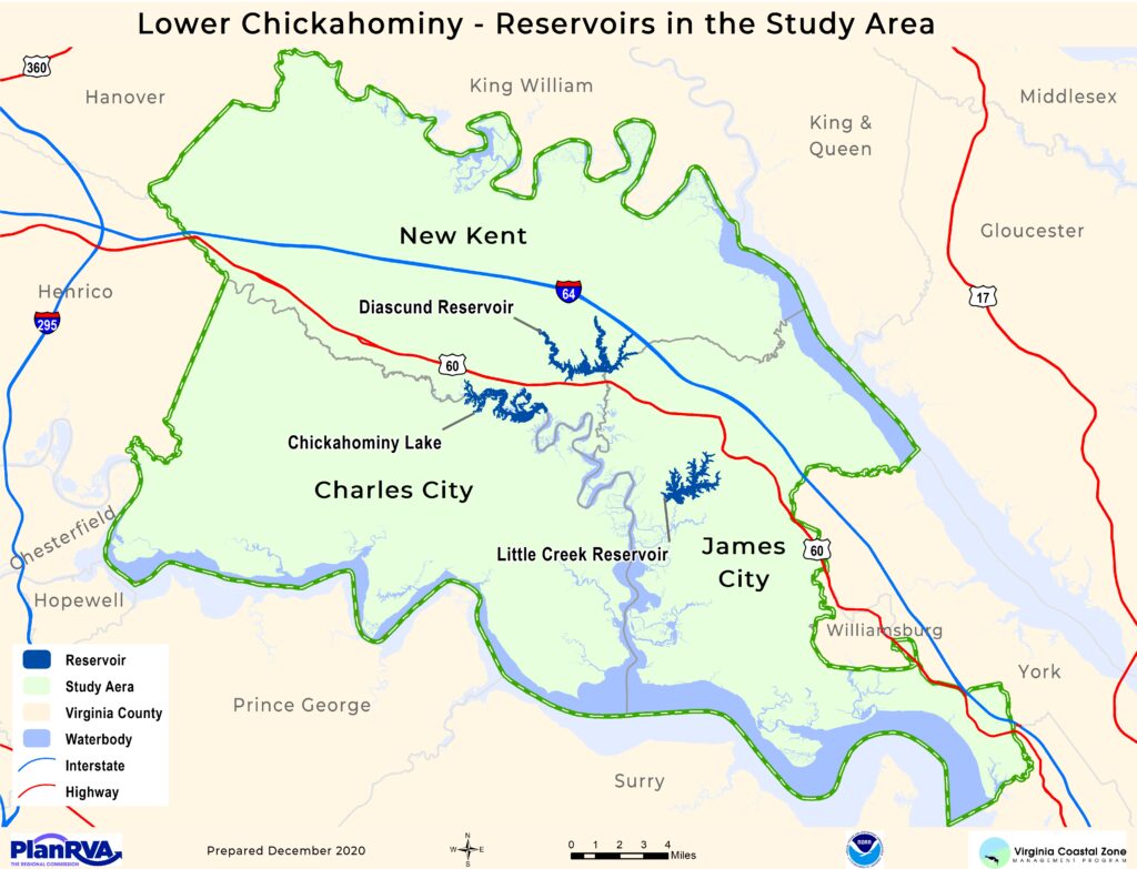
In much of the Lower Chickahominy, residents and businesses rely on groundwater for drinking water through either individual wells or small public or private systems. In contrast, many residents and businesses to the east served by the Newport News Waterworks, including portions of James City County, rely on the natural setting of the Lower Chickahominy area as a drinking water source. Three reservoirs exist in the Lower Chickahominy area:
Walkers Dam stretches across the Chickahominy River between Charles City and New Kent Counties creating Chickahominy Lake. Abundant cypress trees and submerged aquatic vegetation (SAV) provide excellent habitats for fish and aquatic organisms; they are one of the reasons for the consistently good fishing at this lake.
Diascund Reservoir is located along the New Kent and James City County line, this 1,110-acre reservoir offers recreational opportunities for paddlers and anglers via the public boat ramp at Diascund Reservoir Park in James City County.
The Little Creek Reservoir is located in James City County, this nearly 1,000-acre reservoir can be accessed via Little Creek Reservoir Park. Visitors can fish, hike, picnic, paddle, and enjoy the playground.
Conserved Land & Conservation Easements
Conserved Land
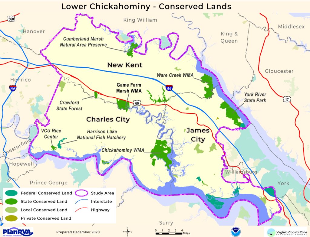
Lands maintained in a natural state protect water quality and natural heritage resources by filtering pollution and providing habitat. Land and water area is included in this category due to ownership associated with limiting development. There are lands across the Lower Chickahominy area that are conserved from development due to public ownership. Some conserved land is owned by non-profit conservation organizations. A few highlights about conserved land in the Lower Chickahominy include:
- Over 58,000 acres of land and water are conserved due to ownership.
- Wildlife Management Areas include more than 8,000 acres.
- The 1,193 acres of Cumberland Marsh Natural Area Preserve in New Kent County along the Pamunkey River are owned by The Nature Conservancy and managed in coordination with the Department of Conservation and Recreation as part of the Virginia Natural Area Preserve System.
- York River State Park is located in James City County along the York River. A portion of the park is designated as the Taskinas Creek Station of the Chesapeake Bay National Estuarine Research Reserve System.
- Located on 494 acres along the James River in Charles City County, the VCU Rice Rivers Center is a field station devoted to research, teaching, and public service.
- 2,781 acres of local parks span the three counties of the Lower Chickahominy.
Conservation Easements
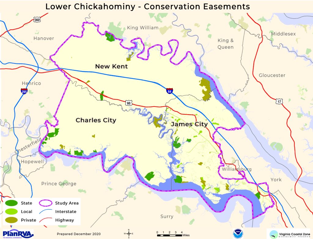
Almost 13,838 acres of land in the Lower Chickahominy area have been conserved through conservation easements. Conservation easements legally restrict the use of land for development permanently. The terms of each easement are unique, but generally, conservation easements maintain land in a natural, undeveloped state passively or in a working manner, such as in agriculture or forestry. Two private non-profit land trusts work with landowners in the Lower Chickahominy area to protect and preserve land: Capital Region Land Conservancy and Historic Virginia Land Conservancy. Other easement holders of land in the Lower Chickahominy include Virginia Outdoors Foundation, State Agencies including the Department of Forestry and the Department of Historic Resources, James City County through a currently paused purchase of development rights program, James River Association, and Ducks Unlimited.
Virginia Water Trails
PlanRVA is collaborating with the Central Virginia Ecotourism Alliance (CVEA) to highlight ecotourism opportunities in coastal Virginia for residents and visitors through the Virginia Water Trails site. To see all that the Lower Chickahominy Region has to offer click here.
Wildlife Management Areas
Three Wildlife management areas are located in the three-county Lower Chickahominy area. Wildlife management areas offer public opportunities for hunting, fishing, hiking, and wildlife viewing.
US Fish & Wildlife Service
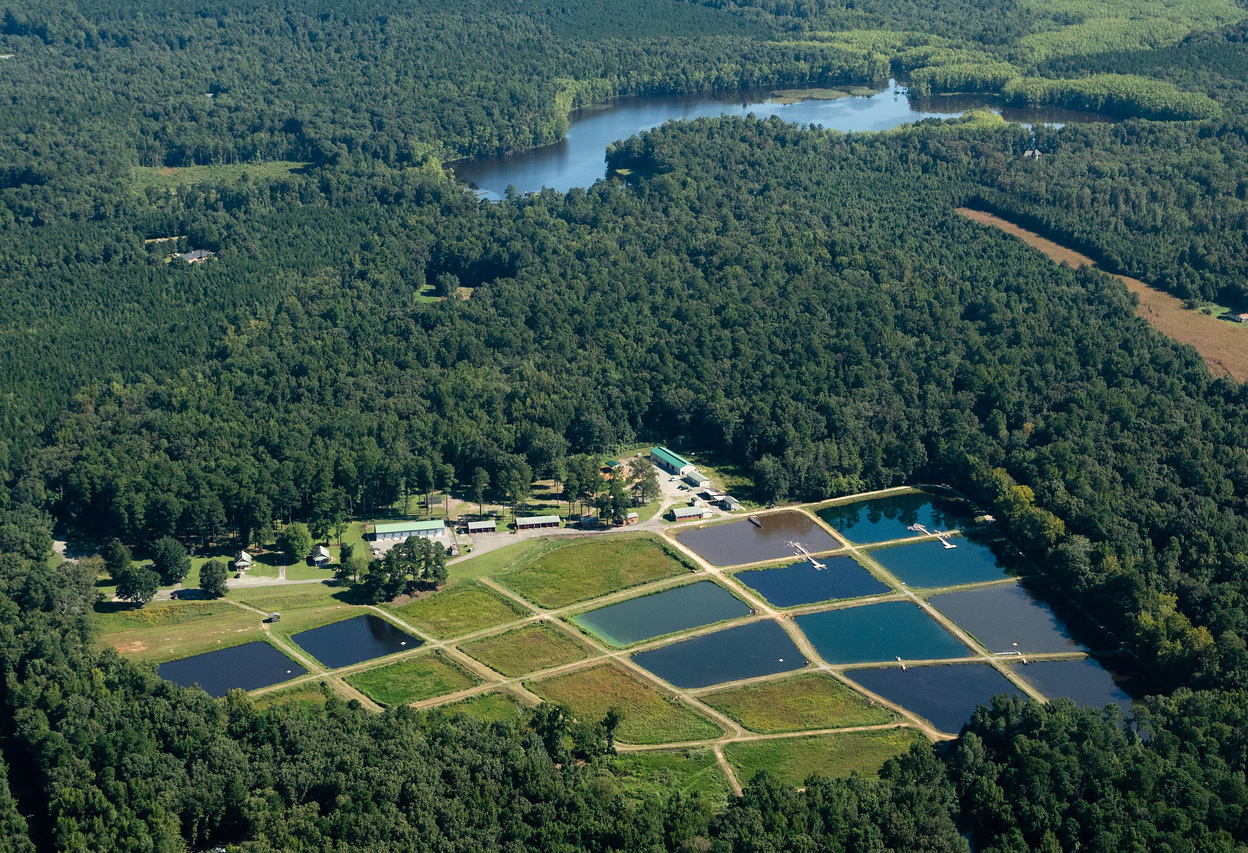
Photo by Will Parson / Chesapeake Bay Program
Harrison Lake National Fish Hatchery, located in Charles City County, produces American shad, alewife, blueblack herring, hickory shad, and stripped bass. The fish hatchery recently added the production of freshwater mussels to recover imperiled species such as the James spinymussel among others.
Project Partner Resources
James River Association
The James River Association maintains a public access mapper for the James River and tributaries, including the Chickahominy River. The user-friendly site includes information about locations including address, website, and amenities.
VA Department of Wildlife Resources
Major Trail Resources
DWR Boating Access Changes
Effective July 1, 2022, any person using a Department of Wildlife Resources (DWR)-owned or managed facility, including boating access sites, must have a valid Virginia hunting, trapping, or fishing permit, a Restore the Wild membership, an access permit, or current certificate of boat registration issued by DWR to use the facility.
Agricultural & Forestal Districts
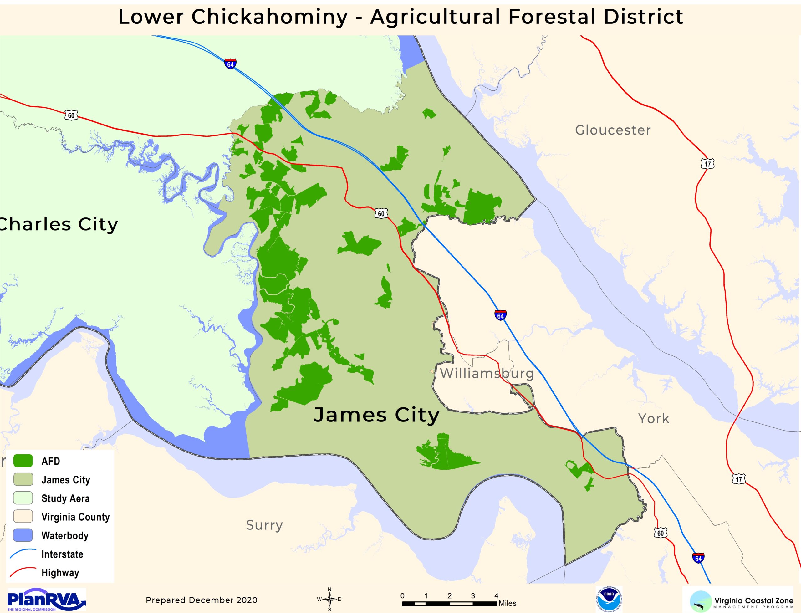
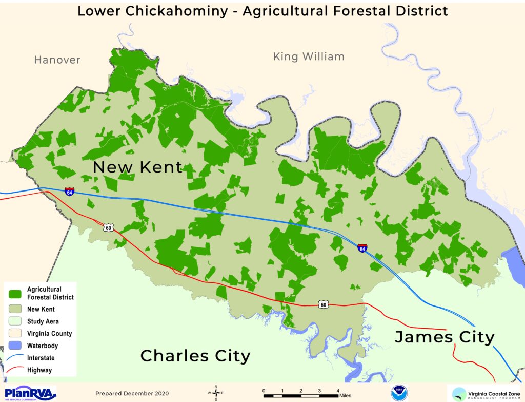
Forests play a vital role in an ecosystem and its many cycles: nutrient cycling, water, and air purification, carbon storage, and more. Deforestation fragments forests, reducing their ability to perform these services. Additionally, fragmented forests can cause plant and animal population numbers to decrease. In 1977 the Virginia General Assembly passed the Agricultural and Forestal Districts Act. Agricultural Forestal Districts, or AFDs, are preserved areas of land that maintain the ecological importance of that space. Residents can voluntarily designate their own land as an AFD if that land continues to be managed and preserved as mandated in a participating locality. After the land is designated as an AFD, this land cannot be used intensively for several years. Find more information on AFDs from VDOF.
AFDs in the Lower Chickahominy localities are available in:
James City County and New Kent County
James City County AFD Map
New Kent County AFD Map
gfhdfghfdgh


