Strengthening Richmond and neighboring regions’ Hazard Mitigation Plan

Hazard mitigation planning is an important process done at the state, tribal and local government levels that aims to minimize the impact of future disasters. Localities are required to have a mitigation plan that is FEMA approved in order to be eligible for FEMA Disaster Assistance. Localities who choose to plan regionally can benefit from the coordinated activities
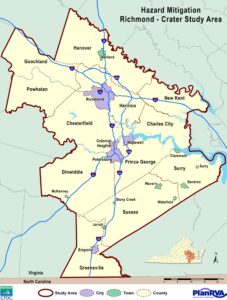
Hazard Mitigation Richmond-Crater Study Area
PlanRVA works with the Crater Planning District Commission on a joint plan that covers 22 localities in the two regions called the Richmond-Crater Multi-Regional Hazard Mitigation Plan. Per FEMA requirements, every five years the plan is reassessed and updated to ensure the collective region is prepared to handle potential disasters and minimize fatalities and loss of properties throughout communities.
The original plan was adopted in 2006, revised and updated in 2011 and again in 2017. In 2020, PlanRVA began the planning process for the 2022 update and tapped Salter’s Creek Consulting to perform the analysis and develop plan document. The current plan that is drafted for public review can be found here.
Here’s a quick look at some of the latest updates made to the Richmond-Crater Multi-Regional Hazard Mitigation Plan.
Hazards and Associated Damages We’re Likely to See
Updates made to the Hazard Identification and Risk Analysis (HIRA) and Vulnerability Assessment reflect data on the most recent hazard occurrences, frequency analysis and annualized damages. For 2022, there were updates made to the vulnerability data for flood, earthquake and wind-related disasters.
Additional updates include:
- A reduced risk for thunderstorms and lightening.
- Considerations to add Radon Exposure and Infectious Disease.
- A revised system of ranked hazards.
The comprehensive plan covers other disaster risks like tornadoes, wildfires, severe winter weather, shoreline erosion and more. All hazard areas identified with a risk analysis can be found in Section 5 of the current Plan drafted for public comment.
What we can do to mitigate risks, reduce vulnerability
Section 7 of the plan, which covers Mitigation Strategy, includes actionable items and serves as the plan for reducing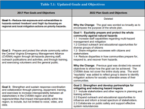 vulnerability to natural hazards across the Richmond-Crater region. During each five-year review, a committee works to remove completed actions and revise and add in new goals and objectives. A table was added to the latest Plan to reflect updates and why those changes were made.
Some of the regional mitigation actions in the Plan focus on strengthening regional strategies for incoming evacuees, integrating mitigation goals and actions into other regional planning mechanisms, providing assistance to communities and residents regarding flood insurance rating policy standards and much more.
Next Steps
The updated plan is currently being reviewed by the Virginia Department of Emergency Management. Once the VDEM review is complete and all required edits are made, PlanRVA will submit the plan to FEMA for review. Oncethe plan is approved for adoption, the plan will be presented for adoption to each local council or board of supervisors within the 22 partner jurisdictions.
To meet the five-year update requirement by FEMA, at least one local government in the study area will need to adopt the plan by August 6, 2022.
More information about PlanRVA and Crater’s Mitigation Planning Process can be found here.
Subscribe to The Better Together Connector
Sign up to receive The Better Together Connector, a quarterly e-newsletter designed to highlight the latest efforts, successes and a look ahead from PlanRVA, the Central Virginia Transportation Authority, the Richmond Transportation Planning Organization, and the Emergency Management Alliance of Central Virginia.