Building Safer Connections Across the Richmond Region

PlanRVA provides support to localities across Central Virginia on projects that aim to create safe and accessible transportation systems for community members.
From ensuring completed sidewalks that lead to and from GRTC bus stops to building safety buffers on high-traffic roadways for cyclists and pedestrians, there are countless considerations that need to be made to ensure projects provide safe and accessible transportation options.
“There is not a one-size-fits-all solution, as needs, funding and planning look different for rural, suburban and urban areas – and all those in between,” said Phil Riggan, transportation planner at PlanRVA. “It’s critical to approach transportation planning from a context-sensitive lens to ensure the final product is inclusive of the needs of community members.”
Prioritizing Context-Sensitive Solutions
Context-sensitive planning recognizes that the needs and preferences of different communities and localities vary widely. This approach helps to create more accessible and equitable transportation systems that serve everyone, including traditionally underserved and marginalized populations.
In conjunction with the Bicycle and Pedestrian Plan, PlanRVA leads Complete Streets, a program that uses a context-sensitive approach to provide safe, comfortable and convenient access to community destinations and public spaces, regardless of age, ability, income, race or ethnicity.
The Town of Ashland was one of the first localities to implement Complete Streets efforts to improve safety and enhance the town’s vibrancy. PlanRVA first worked with Ashland to identify needs and transportation gaps, including aging and damaged sidewalks, and wide lanes with fast speeds that made it difficult for pedestrians to cross. From there, PlanRVA and Ashland acknowledged three immediate opportunities that were relatively low-cost and quicker to implement than large scale transportation improvements.
Other localities in the region are also taking action to make Complete Streets happen by initiating conversations with key stakeholders and bringing multi-modal infrastructure into specific projects.


Enhancing Safety, Accessibility through Multi-Modal Planning
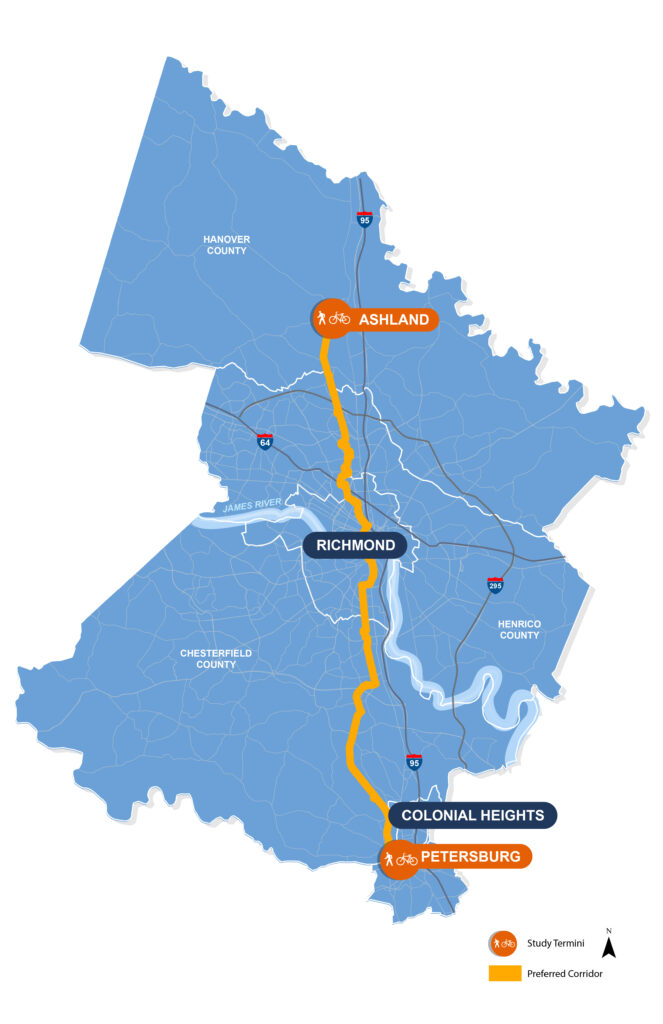
The Fall Line trail courses through seven localities: Ashland, Hanover, Henrico, Richmond, Chesterfield, Colonial Heights and Petersburg. Photo: VDOT
“Whether you own a vehicle, rely on public transit, opt for biking or choose a different form of transportation during daily commutes, we all deserve the right to safe, quality and accessible roadways,” said Riggan.
Multi-modal transportation planning is a holistic approach that recognizes the need for various transportation modes to work together seamlessly. It encompasses a wide range of options, including walking, cycling, public transit, ridesharing, private vehicles and other human-powered or assisted mobility devices.
Many priority projects and transportation goals for 2023 are multi-modal focused and support the development of regional trails, including Vision Zero, BikePedRVA2045 and the Fall Line, among several more. All aim to create safe solutions for community members and enhanced roadways for both traditional and non-vehicular transportation.
“Regional trails can be a great solution for providing safer routes during everyday commutes for those who may not own a vehicle,” said Riggan. “For example, there is a stretch on Route 1 in Chesterfield that is very traffic-heavy with few accommodations for pedestrians or cyclists, and there are GRTC bus stops along the way. Residents need to be able to get to and from these bus routes safely.”
As part of a larger comprehensive plan, Henrico is assessing four-lane roadways and working towards implementing bike lanes or creating a buffer lane. And GRTC has an amenities plan in place which will look at all bus stops system-wide to determine deficiencies and prioritize how those will be resolved.
Addressing the unique needs and challenges of different localities and areas within those is critical for creating safe and accessible transportation networks. It requires input from community members and collaboration and cooperation from local leaders. To stay informed about opportunities for participating in decision making that impacts roadways, trails and other transportation elements in your neighborhood, sign up for our email newsletter below.